
Your Boat License in Florida – Rules and Regulations
- 29. April 2021
- Info
Boating without nautical experience! That sounds like a real challenge. Thanks to the latest navigation technology, the whole thing is put into perspective. In this article we show you what today’s navigation software does and how it helps you to enjoy your boat tour instead of being busy with the interpretation of nautical charts.
Ad
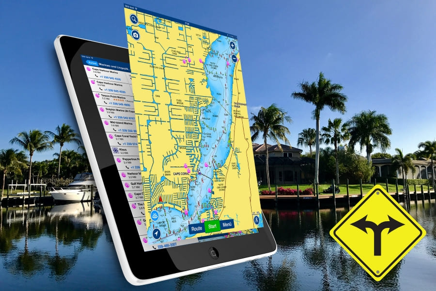
Modern navigation software, like the one used at Speed-Dock on every boat, clearly shows you all the important information you need to guide the boat safely. The ability to put different maps on top of each other in so-called layers allows you to grasp all the important information at a glance and do not have to dig through various maps.
The software shows you where you are anytime. This helps you to focus on the immediate vicinity and the relevant information.
Even before your boat tour, you can plan and save your routes without any ruffle and excitement or you can use the auto-routing function and simply enter the start and end point.
In order to behave correctly with a boat on the water and to protect the boat from damage, you need maps with a wide variety of information. So-called sonar charts show you e.g. the water depth, currents and the structural nature of the sea, river or seabed. Other maps give you navigation aid and show e.g. lights and buoys or point out dangers and obstacles.
In addition, detailed port maps with docks and pontoons, ramps, petrol stations and sights are available.
Electronic cards are a valuable aid when moving on the water with a motorboat. But finding and reacting to all the information you need while driving is a challenge, even for experienced seafarers.
Navigation software is of great added value, especially in unknown waters with treacherous sandbars and shallow water areas.
The software, which is specially tailored to the needs of water navigation, can be operated in a similar way to Google Maps. However, the software takes a lot more information into account when calculating a route automatically than when navigating a street.
The route calculation includes e.g. information about the water depth, existing obstacles, prescribed fairways and specially protected areas.
Even navigation rules are considered, so that general driving errors when consistently following the route are almost impossible.
The route itself is highlighted as a colored line. The position and orientation of the boat is determined via GPS and displayed as an arrow as in conventional navigation devices. An additional help line will help you get the boat on course in time without frantic steering movements.
In addition to the marked route, the boundaries between two depth areas are highlighted in color in shallow water mode. If it is necessary to leave the route due to an unforeseen evasive maneuver, the area in which one can safely move can be quickly recognized by the color delimitation.
This example shows that navigation software has its limits. Although it is a very useful tool, the responsibility to react to circumstances and ultimately to steer the boat safely remains with you. So always keep your eyes open and not distracted when boating.
Planning a route is child’s play on the touch display. After turning on route planning, touching and holding a stopover is enough to add it to the route. However, some knowledge is required to use this function. Otherwise the boat could run onto ground or the route could violate a protected zone.
So, if you don’t know exactly what you’re doing, use automatic route planning.
With automatic route planning, you enter start and destination and let the software make it easy. She will find the fastest way for you and will go about all the navigation skills. On the calculated route the boat is always safely afloat, shallows and obstacles are avoided and everything is according to all the rules of seafaring. It couldn’t be easier.
Predefined destinations or routes are already stored in our navigation software for many destinations in the Cape Coral area. Just have a look in our “Destinations” section to see what there is to explore and select the desired destination from the favorites in the software. And then just enjoy yourself and concentrate on the essentials.
By the way, no matter where you end the day, the back-home function automatically calculates a route back to your starting point, so you are never “lost”.
A real captain not only has to keep an eye on his boat and the water, but also pay close attention to the weather. Anyone who has ever got into a real storm or a heavy thunderstorm with the boat will not want that again. And it can also be dangerous.
Therefore, the navigation software always receives the current weather data of the region in which the boat is located online. In addition to cloud cover and precipitation, wind strength and wind direction thunderstorm warnings are also displayed. It is always a good idea to take a quick look at the weather map before starting a journey so that you do not drive directly into a bad weather front.
Should you ever be surprised by a storm, the first rule is to keep calm and slow down. Keep the boat on course with low speed so as not to drift and, in the worst case, hit a sandbar or an obstacle. Your navigation system will reliably help you stay on course and guide you safely to your destination even in poor visibility.
Here is a brief overview of what our navigation software offers:
• Clear map display
• Display of the current position
• Display of water depth, current and soil structure
• Display of navigation aids
• Color coding of shallow water zones
• Manual and automatic route planning
• Route history
• Favorite destinations
• Ports, jetties, petrol stations, restaurants, bars, shops
• Current weather data
• Internet hot spot
Ad

Dear customer, Cape Coral is a paradise for everyone who would like to experience the adventure of" boating "on their vacation. Have you ever watched manatees and dolphins in the wild? This and much more is possible here in Florida without a boat license. We will help you take a trip on the water that will make your vacation an unforgettable experience. Let us advise you and take advantage of our diverse services at unbeatable prices. Contact us now so we can show you how the adventure becomes a reality. Bastian Riedel - General Manager Speed-Dock


IT WOULD BE NICE TO HAVE YOU ON BOARD;-)
SIGN UP FOR OUR NEWSLETTER
AND RECEIVE $25 OFF
FOR YOUR NEXT BOOKING


Join The Discussion